Lacuna Passage - Devlog #73 - WayStat Navigation and Weather Monitoring
Waypoint Stations (WayStats for short) are crucial science installations that will assist you with your navigation and weather monitoring. In the survival sandbox mode you will need to discover these WayStats and activate them before they're data can be accessed.
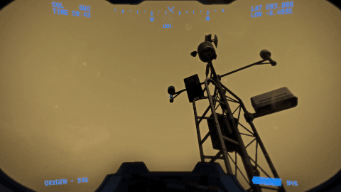
If there are no active WayStats within a certain radius of your location your suit's navigation functions will be offline. As you can see in the images above we have discovered a WayStat, but the HUD at the top shows our navigation is offline. To fix this we must first turn it on.

With navigation features back online we can now see our custom objective marker heading on our HUD compass and our own location in the navigation app on the datapad.
The weather monitoring functions however will require a small upgrade to the WayStat's components. If we try to access the new weather app on our datapad right now we will get a "NA" label at the location of the WayStat.
So you must access the component panel of the WayStat and install a new fuse.
Now when we access the weather app we will get a percent value that represents the visibility at the location of the WayStat. A 100% value means that there is no sign of a dust storm near the WayStat.
A single active weather monitoring WayStat will allow you to check your weather app to see if visibility is reduced, but you will need three active weather monitoring WayStats in order to get advanced warnings for incoming dust storms.
Related to navigation, we have also added a new gameplay purpose for photography. Some game discoveries like WayStats and habitats will have permanent map markers, but others like small supply caches will not. In order to catalogue your discoveries you will need to take photos of them (and perhaps save them to your favorite photos folder). Then you can access them in the photo app and use the "Set Custom Objective" feature to find your way back to their location.

And as you can see in the above gif, we are starting to fill in our landscape with these discoverable locations. 92 semi-randomized locations to be exact. We've only just really gotten started, but here's a closer look at one of the smaller supply cache locations.
As we work towards filling in our survival sandbox with interesting locations to explore we will probably keep most of them a secret so that finding them for the first time will feel like a genuine discovery.
And finally we want to show you how the terrain will improve as we continue to place more unique rock structures. The comparison below shows you the bare terrain from our NASA satellite data and what it looks like after we have manually placed more detailed rock formations.
That covers everything from this last month of development. Thanks for reading and make sure to let us know what you think in the comments.